....Cars could go 80mph, so we never passed one car, but a lot of cars passed us, even though we could go 70mph and did!! As we left the Hill Country and got into West Texas the terrain became more rocky and actually mountainous in spots like this next picture....
Our first stop Saturday night was Balmorhea, TX, about 380 miles. It was called Saddleback Mt. RV Park and advertised a truck stop with a restaurant and saloon...WRONG! There was a "sort of" truck stop, but the saloon and restaurant were out of business...victims of a poor economy. We drove around the RV park and really did like it. There was only one other RV there, pulling a horse trailer. The office for the RV park was in the truck stop, so we went in, paid our $20.00 and parked for the night....It was really a nice place...here is a photo of our spot...
....and here is the sunset we had that evening over the Barilla Mountains.....
The elevation there is 6500 ft. and the nighttime temp was 22 degrees. We chose not to unhook our truck for a fast getaway in the morning..We had 428 miles to go the next day.
On Sunday, Dec. 27th we left Balmorhea at 7AM and drove through West Texas toward El Paso. We opted to take a detour around downtown El Paso and it took us right up the mountains through a beautiful pass ...Here we are headed toward the mountains...notice the snow at the tops....
...and here we are driving down the other side, with a bird's eye view of El Paso.
We drove into New Mexico, through Las Cruces and I-10 took us further West and into a stretch of road that I now remembered. This stretch all the way through New Mexico on I-10 is notorious for terrible dust storms.. It is mostly open dusty ground with blowing sagebrush and the dust storms can give you almost NO visibility. There are signs telling drivers of possible blowing dust and dangerous driving..like this one....
We got safely through New Mexico with no dust storms and were greeted by this welcome sign as we finally hit Arizona....
I JUST LOVE ARIZONA!! The terrain again changed shortly after we crossed into Arizona. This area here reminds me of the old cowboys movies...I kept waiting for an ambush from the rocks......
Here is another area that made me look for Tonto....
We were suppose to stay at a park in Willcox AZ called Sagebrush RV park that night..Den had programmed the address into our TomTom (GPS)...but when we arrived in Willcox and drove down the street where it was suppose to be, we ran into a dead end dirt road...and a few very scary homes, one with a Rotweiller who did't take too well to us driving by him with our big RV. We decided to go another 36 miles to Benson, AZ and hope to find the RV park we had stayed at 6 year ago with the Cougar. As we drove into Benson on the interstate, I happened to look over to the right and recognized the proverbially named "I-10 RV Park"...so we parked the rig and finally rested..Here is our spot for Sunday night....
The weather was still pretty chilly...48 degrees, but the sun was nice and warm. We were now on Mountain time, gaining an hour, Thank God..
.Monday morning (this morning), we left Benson about 7:45 AM, knowing we only had about 200 miles to go to our final destination, Hickiwan Trails RV Park, in Why. We decided to get off the interstate and take a more scenic route, since we had plenty of time. We had taken the same route with our Cougar 6 years ago. It is a pretty narrow road, but very scenic, with mountains and cactus and not much traffic. We noticed a more definite presence of the Border Patrol.
This road goes through the Totono O'Odom Indian Nation. Last time we took it we drove up to Kitt Peak to the Observatory...We learned last time that you really should not haul an RV up a 7000 ft. mountain with a 12 per cent grade, so we passed by and waved to it. As we were traveling, we saw up ahead what looked like police or border patrol flashing lights..I quickly took a picture (quickly is why it is a little blurry), but you get the idea....
As we got closer, we were waved on by a police officer and we noticed a few people off the road in the bush...and as we slowly passed by we saw one car on side of the road in the brush all crunched up. I saw something laying out beside the car and I can't say if it was a human body or an animal, but it was very badly damaged and definitely dead. We passed slowly, and Den saw another car on the left side of the road in the brush on it's hood..You know me, I just gotta document every little thing so here is my next shot...not very clear, but I was a bit shaken......
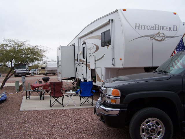
Well, we finally arrived at our park about 11AM, after stopping in Ajo to pick up our mail. It is 4:30PM, and we are all set up, both satellite dishes pointed at the South desert sky, our picnic table out,(thanks Kel and Cin), our chairs set up, and now, my blog complete. I can't wait to show you pictures of the town of Ajo. It is really very beautiful..We will go to town Thursday and I will post some then... Here is our spot for a month in the Arizona desert.....
...and yes, it is cloudy today...but I dont' care!! I love it here!!
And now it is cocktail hour....We are two very weary travelers on a great adventure...and we both need a drink....Lots more to come!!!


No comments:
Post a Comment